In light of the wintry mess that plagued the Midwest during the past few days, I thought it would be fitting to give an overview of the different types of frozen precipitation we see, as well as how they form.
First, a background on any precipitation in the winter. As you gain altitude in the troposphere (the lowest layer of the atmosphere, where most weather occurs), the temperature generally decreases, and there will be a point where the air temperature is below freezing. How high that freezing level is, however, depends on where you are and what is happening at that time. For rain and snow, this is the only thing we need to concern ourselves with. If the freezing level is too high, and it is above freezing all the way to the ground below, the snow that falls will melt upon encountering this warm layer, and fall to the ground as rain. If the freezing level is at the surface (or just a couple hundred feet up) the snow will survive to the ground and accumulate.
Now, as is the case with most winter storms, there is a complicating factor: warm air is less dense than cold air, and tends to come in over top of the stubborn cold air at ground level. This is significant because it can produce sleet or freezing rain, which can be arguably more disruptive than snow, especially for travel.
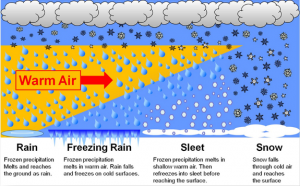
When there is a shallow warm (>32F) layer interrupting the cold (<32F) column of air, the snow that falls through it melts into raindrops, but then exits, and has enough time to refreeze into ice pellets, or sleet, before it strikes the ground. Sleet’s most dangerous property is in its removal; if enough accumulates (say, 4″) it is dense enough to strain the backs and hearts of those who attempt to shovel it, leading to increased medical incidents.
Freezing rain has the same general way of forming as sleet, but the warm layer is deeper, and thus the underlying cold layer is shallower, leaving not enough time to refreeze. So, the droplets stay liquid until they hit the surface, and freeze on contact, creating a glaze of ice, as pictured above. Freezing rain is arguably the most dangerous form of winter precipitation, as even a trace of accumulation can render untreated roads impassible. In greater amounts, freezing rain can weigh down and break trees and power lines, and close even pretreated roadways.
The following image is a visualization of the conditions necessary for each type of winter precipitation:
A parting thought: No matter what kind of precipitation is falling in your area, care must be taken to avoid incident while traveling. All types of precipitation have their own inherent dangers, especially to motorists. So, if you must travel, slow down, leave plenty of stopping distance between yourself and other vehicles, and try to take a route that consists mainly of well-treated main roads.


Leave a Reply