Source: https://www.nohrsc.noaa.gov/
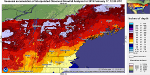
If there was one word to sum up this winter for snow-lovers in southern New England, “disheartening” would just about do it. There has been an unusually stubborn storm track this winter, which has caused a gap in snowfall in most of southern New England for most of this winter, whereas areas north and west of central NH have seen copious amounts of the stuff since it began accumulating in November. The graphic above illustrates this contrast nicely.
Granted, it is perfectly normal for the higher elevations of northern New England to receive more snowfall than those in the southern half of the region, however, the gradient this year along the I-93 corridor (extending N-S through central NH down to Boston, MA) is unusually large. Some locations in the mountains of western ME are approaching record high seasonal snowfall totals, whereas Boston, MA is experiencing a top-10 lowest seasonal snowfall on record to this point. That is to say, above-average snowfall is occurring adjacent to anomalously low snowfall, and with no shortage of precipitation anywhere, this has all to do with the flavor of storms we have seen this winter.
In short, the major storm track this winter has been west of New England, with the systems moving through the eastern Great Lakes. When this happens, New England is on the warm side of the system, with southeasterly winds bringing in warmer air into the region. That said, the mountains in northern New England impede the progress of the warm air through a process called cold-air damming (illustrated below). The influence of this process- and where it keeps cold air deep enough for snow to fall- is confined mainly to VT, NH, and ME. This leaves most of MA, and all of RI and CT exposed to the infiltration of warmer marine air, which causes a changeover to rain in these areas.

Source: https://en.wikipedia.org/
Apart from this type of storm focusing snowfall in northern New England, the lack of a storm tracking nearby offshore- which historically produces most of southern New England’s snowfall- has just as much to do with this snowfall discrepancy. It is the lack of a typical Nor’Easter that has resulted in the below-average snowfall in these areas, as the above average snowfall in the north is attributed to the inland storms.
While the time left for this deficit to be corrected is waning, the good news about this discrepancy is in that the ski resorts are having a great season in the north, and the major population centers in the south have been spared some major impacts they would otherwise have had to deal with. Time will tell whether this trend continues and if it turns out saving southern New England in road maintenance costs.
A final thought: I’m hesitant to blame climate change for this winter’s character, as the stubborn storm track seems to be purely coincidental, and that places in the mid-Atlantic states have seen a few significant snowstorms this season so far. The ingredients have been there (cold air, a disturbance in both jet streams, and moisture), but they have just not produced a classic Nor’Easter yet this winter. Perhaps this is in repayment for last winter, when they were exceedingly plentiful, especially in late February and March.
Leave a Reply