Source: https://services.dat.noaa.gov/
This past Sunday saw a major tornado outbreak in the Deep South, with the most devastation coming from one in particular, which was rated an EF-4 and carved a path through east-central Alabama. According to preliminary NWS data, the tornado caused 23 deaths and nearly 100 injuries, not to mention catastrophic damage to homes and infrastructure. Unfortunately, violent tornadoes such as these are a harsh reality for the southeast quadrant of the contiguous US, especially in the spring. To understand why they are so common in the spring, we must first understand what ingredients are necessary for tornadoes to form.
The first three ingredients are necessary for any severe thunderstorms to take place. They are lift, instability, and moisture. Lift is any atmospheric mechanism that forces air at or near the surface to rise- this can be a front, a low pressure system, or upslope winds on mountain ranges. In the case of these tornadoes, a low pressure system drove a strong warm front across the region, which provided more than enough lift for thunderstorms to form.
The next ingredient is instability. In layman’s terms, it is the tendency for air to rise once it is forced up in the atmosphere. For air to be unstable, meaning the air at lower levels wants to rise up through the atmosphere, it needs to be less dense at the lower levels then above it. Warm, moist air at the surface and cold air aloft provided for a very unstable environment on Sunday, also contributing to the formation of the severe thunderstorms.
Moisture is the third ingredient, and the most basic to understand. You can’t really have thunderstorms without some influx of moist air (which also ties into the instability factor, as moist air is less dense than dry air), which we saw in the south on Sunday, courtesy of a southerly wind off the Gulf of Mexico, a major source of atmospheric moisture for the entire eastern half of the country.
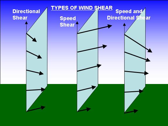
The final ingredient, and the most crucial for tornado formation, is wind shear. Simply put, it is how the wind changes as you go up in the atmosphere- it can get stronger and change direction (as shown in the graphic). High levels of wind shear, both directional and speed, are necessary for strong tornadoes to form, as was the case Sunday. To understand how this causes tornados to form, simply hold a pencil between the palms of your hands, turned horizontally. Move the top hand faster than the other; the pencil will roll, similar to what happens in the atmosphere under these conditions. Thunderstorms can then take this horizontal rotation and turn it vertical, and eventually spin up a tornado.
Final thought: with spring nearing, this promises to be only the beginning of more devastation in the coming months, as these conditions will be present numerous times this season (perhaps as early as this coming weekend). This is why it is essential for those in tornado-prone areas to know what to do when faced with the sort of scenario that impacted the Deep South this past weekend, and be prepared to do so. Information on how to prepare is available here.

Leave a Reply