Posted by: lc1110 | February 16, 2019

Ongoing Californian Onslaught


A series of intense storms have battered the west coast, perhaps most severely in California, where mudslides, flooding, and heavy snowfall in the Sierra Nevada mountain range have made for very dangerous conditions over the past week or so. With more storm systems approaching for the next several days, conditions are likely to deteriorate.

One might think, “this is the rainy season, so why would a few storms cause so much chaos?”

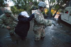
The most destructive forces of these storms isn’t the precipitation, nor the flooding it causes, rather it is the mudslides that have become ever more frequent and widespread in recent years. The reason for this is the increasing occurrence of wildfires in the now longer dry season. When a wildfire moves through an area, the vegetation- and its root system- is taken away, and thus the soil on steeper terrain isn’t anchored by anything (and is unable to absorb as much moisture), thus a once-normal precipitation event can knock it loose, unleashing devastation downhill, causing scenes like the image above to unfold.

The recent mudslides and associated problems in California are wintertime manifestations of a larger problem: climate change-induced drought. The summers in the western US are becoming longer, hotter, and drier, leading to increased incidence and severity of wildfires, with some of the most destructive occurring as recent as this past summer. If this trend continues, the problems caused by precipitation-when it does fall- will only become more and more disruptive.

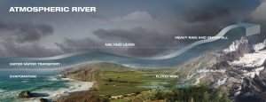
Granted, the observed storms have been stronger than usual, each tapping into deep tropical moisture as far away as Hawaii, via an atmospheric river. In a nutshell, an atmospheric river is a narrow “stream” of unusually moist air aloft associated with a mid-latitude cyclone, and although they can occur anywhere in the mid latitudes where there is sufficient moisture, their impact is arguably felt most by the North American west coast. The following diagram displays the impacts of a “landfalling” atmospheric river.

A final thought: despite all the ski resorts in California enjoying record snowfall due to these recent storms, those residing near burn scars left by recent wildfires are being plagued by fires that have already been extinguished. I’m reminded just how destructive and productive the weather can be at the same time.
Posted by: lc1110 | February 9, 2019

Winter Precipitation Types, Explained


In light of the wintry mess that plagued the Midwest during the past few days, I thought it would be fitting to give an overview of the different types of frozen precipitation we see, as well as how they form.

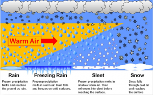
First, a background on any precipitation in the winter. As you gain altitude in the troposphere (the lowest layer of the atmosphere, where most weather occurs), the temperature generally decreases, and there will be a point where the air temperature is below freezing. How high that freezing level is, however, depends on where you are and what is happening at that time. For rain and snow, this is the only thing we need to concern ourselves with. If the freezing level is too high, and it is above freezing all the way to the ground below, the snow that falls will melt upon encountering this warm layer, and fall to the ground as rain. If the freezing level is at the surface (or just a couple hundred feet up) the snow will survive to the ground and accumulate.

Now, as is the case with most winter storms, there is a complicating factor: warm air is less dense than cold air, and tends to come in over top of the stubborn cold air at ground level. This is significant because it can produce sleet or freezing rain, which can be arguably more disruptive than snow, especially for travel.

When there is a shallow warm (>32F) layer interrupting the cold (<32F) column of air, the snow that falls through it melts into raindrops, but then exits, and has enough time to refreeze into ice pellets, or sleet, before it strikes the ground. Sleet’s most dangerous property is in its removal; if enough accumulates (say, 4″) it is dense enough to strain the backs and hearts of those who attempt to shovel it, leading to increased medical incidents.

Freezing rain has the same general way of forming as sleet, but the warm layer is deeper, and thus the underlying cold layer is shallower, leaving not enough time to refreeze. So, the droplets stay liquid until they hit the surface, and freeze on contact, creating a glaze of ice, as pictured above. Freezing rain is arguably the most dangerous form of winter precipitation, as even a trace of accumulation can render untreated roads impassible. In greater amounts, freezing rain can weigh down and break trees and power lines, and close even pretreated roadways.

The following image is a visualization of the conditions necessary for each type of winter precipitation:


A parting thought: No matter what kind of precipitation is falling in your area, care must be taken to avoid incident while traveling. All types of precipitation have their own inherent dangers, especially to motorists. So, if you must travel, slow down, leave plenty of stopping distance between yourself and other vehicles, and try to take a route that consists mainly of well-treated main roads.


Posted by: lc1110 | January 29, 2019

Thoughts on President Trump’s Mockery of Climate Science

The media response to Trump’s recent tweet regarding how he thinks the record cold outbreak this week (more details here) disproves the phenomenon known as global warming can only be described as “huge.” All joking aside, I did manage to find a hidden bit of useful knowledge (likely unintended) in what is otherwise an insult to all who study or care about the world’s climate.

Before I delve into that, I will summarize and rebuke the fallacies contained in his tweet. Essentially, he is claiming that the notion that the global climate is warming due to human activity is false all because it is dangerously cold in the Northern Plains. To be frank, this is untrue. There is overwhelming scientific evidence and expert agreement that the Earth is warming as a whole, and we’re all to blame.

So what did the President technically get right?

It’s all in his terminology. The term ‘Global Warming’ is misleading to begin with, as it implies the entire globe is warming uniformly. By this definition, I will agree with President Trump that global warming isn’t true. That said, he probably won’t agree (at least publicly) with me when I say that what he meant to say was ‘Climate Change,’ and that this is most certainly occurring. The manifestation of climate change is in anomalies- departures from average conditions- which are not hard to find when looking at temperature maps of the Earth’s surface.

What the President refuses to see is that other regions of the planet are experiencing unusually warm conditions at the same time as this arctic outbreak in the US. And the kicker is that the warm anomalies are much more expansive than cold anomalies, validating the concept of climate change on a global scale.

Trump (and unfortunately, many others) have subscribed to the scientifically irresponsible thought that “It’s cold where I am, so there’s no way the whole world can be getting warmer.” This is not how the Earth system works. For one place to be anomalously cold, another area must (usually) be anomalously warm, which is what has occurred over the high arctic, namely Alaska which, curiously, is an all-too-ignored part of the US, despite seeing some of the most anomalously warm conditions in the world in recent years.

It may be an accidental technicality, but you have to give credit where credit’s due, right?

Posted by: lc1110 | January 26, 2019

Extreme Cold Outbreak to Invade Northern Plains


The middle of next week looks to be downright dangerous in the north-central contiguous US with morning lows predicted to approach -40 degrees F, discounting the effect of the wind, which will also be in play. When factoring in the effect of 10-20 mph winds to these temperatures, wind chill values will likely reach -60 degrees F.

So why is it going to be so cold?

The first reason is in where the air mass is building right now, locked in over the north pole, where it will be getting progressively colder until it is forced southward. The second reason is just how quickly the air mass will be losing latitude- it takes less than 48 hours to cross the US-Canada border from its start over the icy Arctic ocean. This leaves little in the way of time for the air to modify, as most do, during its southward trek.

The driving force behind this mass movement of air is a fairly potent cyclone over eastern Canada, made possible by a favorable jet stream configuration (a deep trough over eastern North America), that will act to drag down the bitterly cold air directly from within the Arctic Circle.

In addition to the potentially lethal health impacts from exposure to this degree of cold and wind, commerce and school may need to hold off for at least a few hours on Wednesday. This is due to my thinking that car batteries (and those of trucks and school-buses) will have a tough time generating the power necessary to start these engines in these temperatures.

Luckily, this air will not stick around for long, as the current forecast is for the core of the cold air to retreat eastward, all the while moderating, leaving the region mostly above zero (much more tolerable for this part of the world) for the upcoming weekend.

Image source: https://www.tropicaltidbits.com/

Posted by: lc1110 | January 16, 2019

Hello world!

The topic of this blog is mainly centered around current events in meteorology, as well as delving into some of the scientific reasoning behind such events. I chose this because I am passionate about the weather and have been for all my life, and now studying meteorology at Plymouth State University, I now have more understanding of the fascinating processes behind what the weather does.

« Newer Posts

Categories